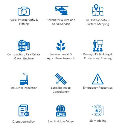
GROUPS OF ATUL is a Drone (UAV) Survey, mapping, inspection & publications company in Nasik, India.
mission is to improve the human condition by turning knowledge into practice. We help our clients integrate drone technologies and solutions into their current business processes for meaningful human and business impact.
Our Mission
- GROUPS OF ATUL has based its Premises in Nasik and has Successfully completed 25 years of industry experience. We have the best professionals in this technology and has a top technical team, who bring adequate experience in Spatial Technology Fields. The team has tied-up with some of the best international companies/ agencies & partners at National and International level to leverage business & benefits.
- We brings horizontal and vertical integration of Satellite/ Aerial/ UAV Photography, LiDAR, Positioning Applications, GIS Databases and applications, GIS Web-services.
- Our team with its vast experience and expertise, provides the company the strength to offer innovative, quality and effective solutions to all sectors of government, private enterprises, Academia and Non-Government organizations.
How Does it works?
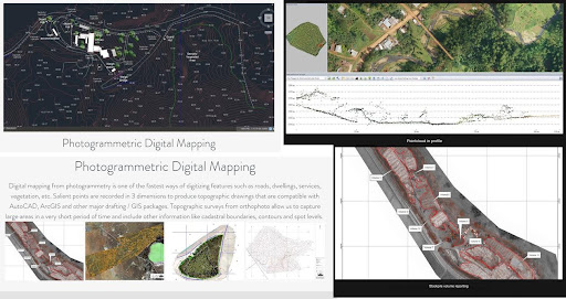
- Our specialty in High as well as LOW Altitude Precision Aerial 3D data capture & photogrammetry services with innovative multispectral sensors & camera technologies in the areas of UAV drone surveying, 3D mapping, GIS surveying with analysis, topographic survey with Centimeter level accuracy.
- 3D models of practically any size infrastructure with actual dimensions with periodic progress monitoring, expertise in periodic inspection of any land/ property development activity, Water shed planning survey/ analysis, DAM 3D inspections, Dumping grounds volumetric surveys, Mining site precision 3D surveys, Agricultural surveys with Multispectral & Thermal sensors, vegetation mapping, crop health monitoring for better crops, Forest conservation surveys.
- Environment sensitive areas in-depth 3D mapping is very important subject of today’s world. With our Aerial 3d mapping technology, we can initiate Periodic Surveys for the change’s assessment of the Eco sensitive areas repeatedly. Forest, Mangroves conservation, beach erosion- pollution control & the quality of the coastal environment.
- We work on improving safety, reducing costs and ensuring quick turnaround time on projects. Our mission is to assist Government, NGO’s & Corporates to fully understand, maintain and protect their most valuable assets.
- Customer satisfaction is our goal. To cater this, we are equipped with latest aerial technologies in country. We have a team of experienced UAV technicians, drone pilots, Photogrammetry experts, Archeology experts, planners, mining consultants, wind turbine experts, agriculturists, creative photographers, aerial cinematographers, graphic designers, Content writers.
- We provide our aerial photography services all over India, with an aim to reach every corner of our country with the help our advanced innovative technological services
How Does it works?
Drone Survey Methodology:
Planning Drone data collection Drone data processing & corrections Generation of desired maps Analysis & Desired Report generation.
- Our Drone data provides most valuable insights in terms of evaluation, planning, site operations and maintenance, thereby reducing the groundwork. We work with a variety of Large, compact and portable UAV platforms suitable for varying situations. Ground Sampling Distance or resolutions being as high as up to 1cm per pixel.
- UAV or Drones along with exciting new image-processing algorithms are driving a fundamental change in how data aggregation takes place whilst providing quick, economic, safe and accurate drone survey in India.
- UAV Surveying in India has helped many companies to get georeferenced imagery of their land. Offering 10 times the clarity than Google earth maps, it’s easy to identify objects on ground.
3D Photogrammetry/ Mapping files:
- Mapping files will be delivered in any of the following Autodesk compatible formats:
- DWG, DFX, 3DP, CSV,JPG (RGB Image)
- Available for all 2D layers: 2D Map, Elevation, and Plant Health.
- Includes .KML file and .TWF file with the georeferenced metadata.
- GeoTIFF
- Includes a.TWF file with the georeferenced metadata.
- File format suited for 2D analysis in GIS software such as ArcGIS or QGIS.

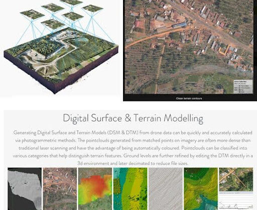
3D models (Raw Elevation Values – DEM)
- LAS
- (Point Cloud)
- las point cloud
- Can be used in AutoCAD, ArcGIS, Global Mapper, Applied Imagery, or similar software
- xyz point cloud that contains RGB information (XYZRGB). Resolution is specifiable
Our Expertise:
Geo Spatial Databases & Development:
- GIS Data Migration – Scanning, Digitization, Geo-rectification & Database Creation
- Data Conversion – Design drawings, Document Management
- Satellite Image Procurement, Processing & Value Addition
- Photogrammetry
- LIDAR Data Acquisition and Processing
- GIS Software Development & Solutions
- Training & Consulting – GIS, RS, Photogrammetry & Capacity Building
Geology & Mining:
- Geological Mapping using Satellite Imagery for Identification of mineralization zones (including Gold and Precious Stones)
- Preparation of Base Maps using Satellite/Aerial Imagery
- DGPS Survey and GCPs Collection for Geo-Referencing
- Geochemical prospecting of mineral blocks
- Geo-chemical sampling
- Desktop studies and due diligence
- Prognostic Modeling for identification of mineral anomalies
- Recommendation for Mining Exploration.Seismic Risk Micro-Zonation & Mapping
- Bore Log Image Interpretation
Utility & Infrastructure:
- Corridor Studies – Transportation & Utilities
- Ground Penetrating Radar (GPR) Surveys for Underground Utilities
- GIS for Real Estate
- Site Selection for Siting of Industries and Plants
Agriculture, Forestry & Environment:
- Agriculture Land Use
- Mapping the Crops using Satellite Imagery
- Crop Acreage and Yield Estimation
- Green Belt, Urban/Rural Tree Census
- Natural Resource Mapping for Land Cover, Land Use, Wasteland, Wet Land, Land Degradation, Geology, Soils, Hydro-Geo-Morphology, Hydrological Survey and Area Drainage Studies, Change Detection.
- Environmental Impact Assessment and Environmental Development Plan
- Clean Development Mechanism (CDM)
- Corporate Social Responsibility (CSR)
- Corporate Environmental Management
- Environmental Training and Awareness
- Management System Audits
- Green House Gases (GHG) Accounting and Carbon Foot Printing
- Eco-tourism Services
Land Surveys:
- Ground Control – GPS,DGPS,RTK
- Terrestrial LiDAR
- Point of Interest (POI) /Landmarks and Route Mapping
- Ground Penetrating Radar (GPR) Surveys for Utilities
- Aerial Photography and LiDAR
- Geo-Physical Survey
- Hydrological Survey
- Geo-Technical Investigation
- Geo-Chemical Sampling & Survey
